Conserve Global (2026)
Agrobiodiversity in an Area of Rapid Ecological and Socio-Economic Transformation
Project Details
Last Updated: March 27th, 2026
Background
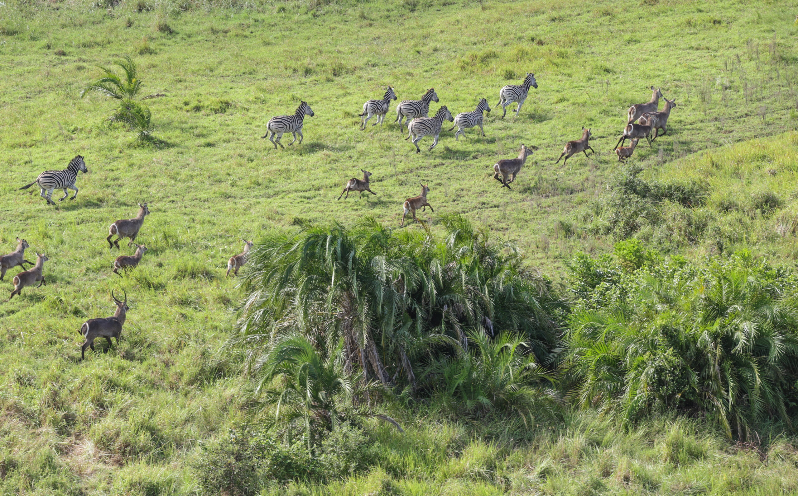
This project in southern Mozambique’s Mwai Community Concession Area (MCCA) focuses on documenting and conserving agrobiodiversity in a region undergoing rapid ecological and socio-economic transformation. The overarching objective is to investigate how agrobiodiversity is shaped, sustained, and threatened in these landscapes, focusing on species and ecological interactions that support the resilience of food ![]() production systems under pressures such as resource harvesting, and land conversion. It aims to establish foundational indigenous and scientific knowledge, analytical tools, and local capacity for effective agrobiodiversity management. Key activities include comprehensive assessments, detailed surveys, expert interviews, focus group discussions, and literature reviews to understand existing knowledge and challenges, and the co-creation of management plans with local communities. Potential impacts include enhanced local capacity for participatory monitoring, data-driven recommendations for sustainable management, more sustainable resource harvesting, and improved food security or renewable income through the conservation and inclusive development of biological and cultural resources. These impacts will be measured through resource maps, management plans, and the upskilling of local champions.
production systems under pressures such as resource harvesting, and land conversion. It aims to establish foundational indigenous and scientific knowledge, analytical tools, and local capacity for effective agrobiodiversity management. Key activities include comprehensive assessments, detailed surveys, expert interviews, focus group discussions, and literature reviews to understand existing knowledge and challenges, and the co-creation of management plans with local communities. Potential impacts include enhanced local capacity for participatory monitoring, data-driven recommendations for sustainable management, more sustainable resource harvesting, and improved food security or renewable income through the conservation and inclusive development of biological and cultural resources. These impacts will be measured through resource maps, management plans, and the upskilling of local champions.
Project Details
The primary activities planned in this project include:
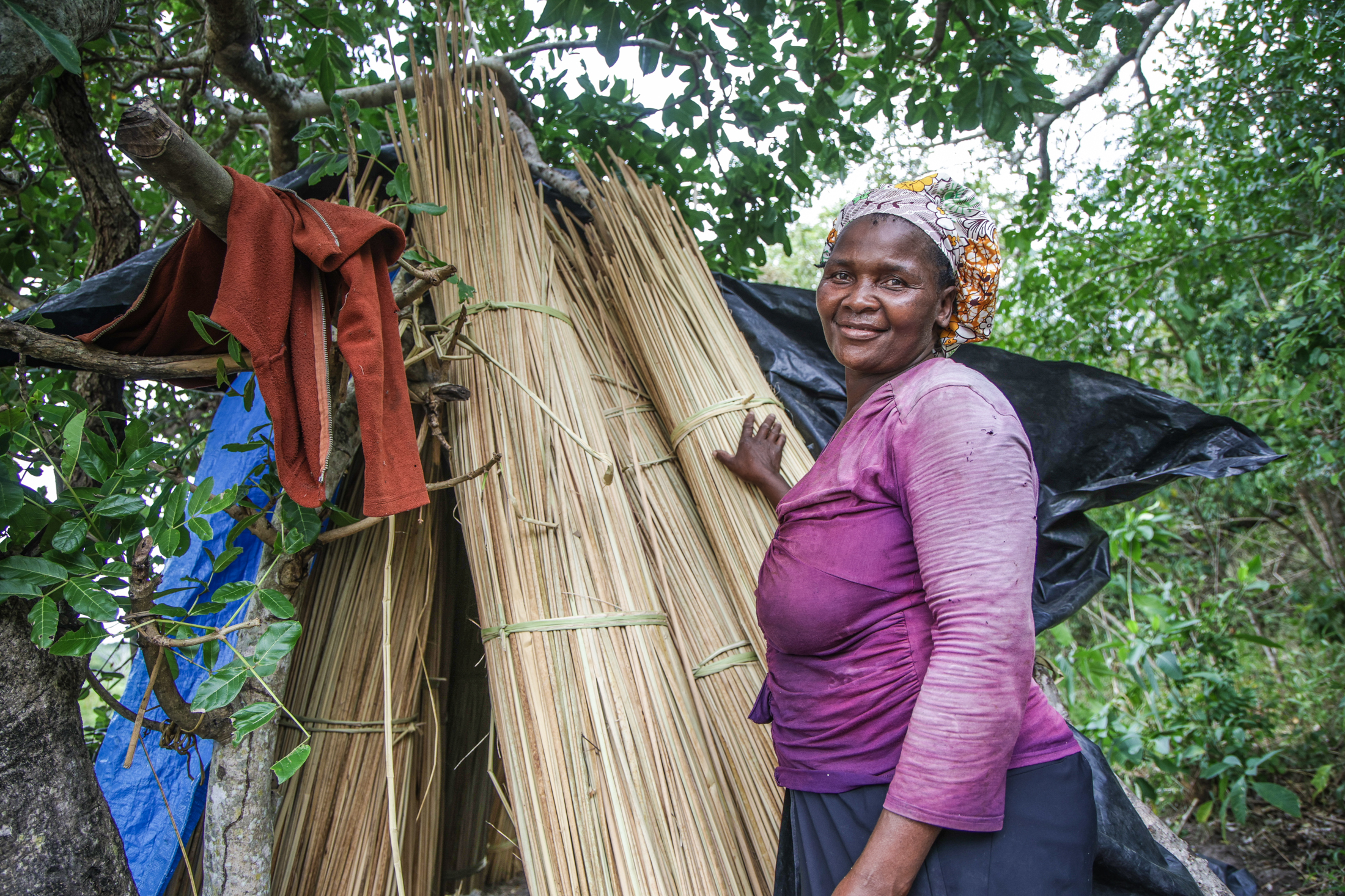
- To identify and better understand important agrobiodiversity and associated plant use systems in MCCA and its adjacent community areas through a combination of literature-based, socio-economic, and participatory research methods, with a focus on species of food, household, medicinal, and cultural significance.
- Perform a desktop review of locally occurring plants might be important for food, medicinal, household or cultural use by local communities.
- Conduct a high-level market survey to determine which native plant species are sold or traded at the informal markets located in the project area, including Salamanga, Maputo, Phuza, and
- Interview experts/key informants: including scientists, managers, practitioners, and community members – to develop a comprehensive inventory of which plant species are used and how.
- Conduct focus group discussions (FGDs) with community groups across the six villages in MCCA, including traditional healers and leaders, to confirm which species and functional groups are most important to the communities (e.g., fruits, wild coffee, and medicinal trees), where these resources occur, and identify and understand the challenges communities face in accessing and using these floral agrobiodiversity species.
- Facilitate a resource mapping exercise within the MCCA and surrounding community areas, engaging local community members to identify important resource areas through the participatory approach of the Gender Action Learning System (GALS) and associated tools.
- Mentor four local champions throughout this process with the aim of supporting them to become community agrobiodiversity monitors.
- To identify patterns in agrobiodiversity, land use pressure, and potential ecosystem change by investigating vegetation structure, species diversity, and baseline population structure for key species across land cover types inside and outside the MCCA using integrated field-based surveys, remote sensing, and spatial analyses.
- Perform a review of scientific literature to develop an understanding of the life history traits, utilisation patterns and demographic drivers of the most important species identified under Objective 1.
- Undertake a remote sensing and spatial analysis exercise of the MCCA and broader area and use the data to generate comprehensive high-resolution land cover and vegetation maps.
- Conduct vegetation surveys (n=100; 50 inside the concession and 50 outside) ensuring that all land cover types are sampled using the Adapted Point-Centred Quarter (APCQ) methodology to record species, levels of utilisation, identify hotspots of land-use conversion and ecological threats (fire, floods, invasive species, and over-grazing).
- Carry out in-field soil sampling and analysis at each vegetation sample plot (n=100) to allow for assessment of potential correlations between soil health, visible drivers of change at the sample site (such as fire, browsing pressure, harvesting pressure, alien invasive species), and species patterns (presence/absence, abundance, recruitment).
- Conduct GIS training workshop for the MCC team, selected community members, and selected ANAC and Maputo National Park (MNAP) staff, to help build basic technical skills to work with spatial data in relation to natural resource management and Focus will be given to working with existing data (as produced above) to identify hotspots of agrobiodiversity, data collection (participatory mapping using GPS devices or smart phones equipped with EarthRanger), data management and to support land use planning through outputs from GIS.
- Provide in-field capacitation for two students from UEM, who will learn how to use the APCQ methods, do the collection and the sampling.
- Provide in-field training and capacitation of a small team of community members (four) as local champions to become community agrobiodiversity monitors (collection of data on species regeneration on Earth Ranger) and equip local leadership with the skills to continue participatory monitoring beyond the project.
- Convene a joint workshop between MCC, Peace Parks Foundation, ANAC, UEM, and MNAP to review the outcomes of the spatial analyses and discuss implications for long-term landscape-level planning
4. To co-create a sustainable agrobiodiversity land-use plan for the MCCA and adjoining community areas by leveraging the traditional and scientific knowledge collected under objectives 1 and 2, fostering knowledge-sharing across stakeholder groups, and building local capacity for data collection, analysis, and interpretation.
-
-
- Engage with partners and other practitioners on best practices for harvesting and other resource utilization that allow for natural recruitment and sustained resources (bark harvesting, seed banks, zonation, AIS clearing, etc.).
- Enhance understanding of agrobiodiversity planning and natural resource management among community leadership structures by embedding regular feedback and consultation throughout the course of the project as part of ongoing institutional governance strengthening.
- Host one learning exchange visit for community members and representative community leadership to observe case studies, improve understanding of best practices, discuss with peer community practitioners, and observe potential benefits and what works (or doesn’t).
- Organize three participatory workshops with key local community members and stakeholders in the MCCA to work together on the development of a floral agrobiodiversity management plan – the first workshop to present the project work; the second to feed back survey results (maps, species lists, threat analyses) and use them to start co-design solutions; the third one to develop and finalize the management plan. The plan may include elements like land-use zoning within the concession (e.g., designating specific forest patches for strict protection or controlled use), harvest calendars for wild products, or community protocols for sustainable resource use.
- Host two project site visits for key stakeholders and policymakers representing ANAC, MNAP,PPF, and the Ministry of Agriculture, Environment and Fisheries (MAAP) – one at the beginning of the project to validate the planned approach and another gathering at end of project to present and discuss finding in the context of recommendations for improved and sustainable floral agrobiodiversity management of the broader APA.
- Develop a comprehensive case study with project findings to be shared with landscape partners and other stakeholders – including government agencies from agriculture and conservation and national-level policy makers.
-
These activities are designed to generate strong data, develop local capacity, and collaboratively create solutions with local communities and stakeholders.
Project Director Biography
Harriet Davies-Mostert – Conserve Global: Director of Impact
Harriet bridges science, management, and policy to promote evidence-based conservation across Africa. With expertise in large carnivore conservation and applied science, she spent 23 years at the Endangered Wildlife Trust, building its Conservation Planning and Science Unit. Harriet is Regional Vice-Chair for East and Southern Africa for the World Commission on Protected Areas, holds an MSc in Tropical Resource Ecology and a Doctorate from Oxford’s WildCRU, and has published more than 50 scientific works. She is committed to helping Conserve Global create lasting conservation impact.